Kibungan, Benguet
Kibungan is a 4th class municipality in the province of Benguet, Philippines. According to the 2000 census, it has a population of 15,036 people in 2,949 households.The 2007 census reveals an increase of 15,700 (NSO 2007 Population Census) in the total population.
The municipality is located 62 kilometers north of Baguio City.
|
History
Available historical records show that the municipality of Kibungan is one of the original thirty one (31) “Rancherias” of “Distrito de Benguet” during the Spanish Regime. Distrito de Benguet was one of the Mountain Region organized into six “Commandancias Politico Militar” which was established by a Spanish Commandante named Don Guillermo de Galvey in November 25, 1864. When the Americans came, the Philippine Commission of the first Philippine Civil Government enacted Commission Act No. 48 on November 22, 1900, which led to the organization of local civil governments in the formerly organized Spanish Rancherias into townships with appointed leaders called “Presidentes”. From 1945 to 1952, the municipal officials were informally elected through a process involving names of colors assigned to the candidates. The formal election of municipal officials started in 1953 through secret balloting. This process was carried up to the present. There were 19 townships that constituted the Province of Benguet up to the time when Benguet was a sub-province of Mountain Province on August 18, 1909. The enactment of Commission Act No. 2877 on February 4, 1920 brought the abolition and merging of townships and sub-provinces plus, reducing the sub-province of Benguet into thirteen (13) towns. In 1938, the thirteen towns were later renamed into thirteen Municipal Districts. About 97% of the inhabitants of Kibungan are Kankana-eys, but other tribes like Ibalois, Bontocs, Pangasinan, Tagalogs etc. are now found in the municipality. The people of Kibungan still celebrate the “canao” or the butchering of animals for the tribal feastings with songs and dances. This was practiced long before and even after the American Regime started formal education in the country. |
Geography
Kibungan is popularly known in the province as the “Switzerland of Benguet” because of its pine trees and rocky mountains. Deep ravinces and cliffs separate and isolate many of its sitios and some of its seven barangays. Although some plateaus, hills and small valleys can be seen in the locality, Kibungan is dominantly mountainous. Aside from its beautiful mountains and century-old rice terraces, Kibungan has many rivers and streams. Waterfalls on high cliffs decorate the mountains especially on rainy days. Many streams contribute to the formation of three big rivers that join the Amburayan River in Kapangan and eventually drain to the South China Sea. The streams and rivers are rich with shrimps, ells and other fishes that can thrive only in the mountains. Hot springs are also found at the foot of some mountains. The municipality is within the cool highland mountainous zone with elevations at more that 2,500 meters above sea level. Generally, the slope is more than 18°. During its coolest months of December and January, Barangay Madaymen experiences chilling temperatures of 0° centigrade, causing the famous “Snow of Madaymen.” The wet season is experienced from June to October and the dry months are from November to May. |
Landmarks and Monuments

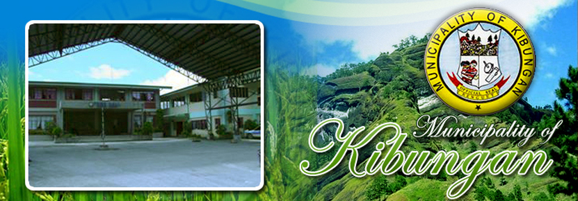
Kibungan Municipal Hall
At the Poblacion, 62 kilometers or 3.5 hours ride away from Baguio City, on a site accessible to all its constituents.
Construction of the Municipal Annex Building, adjacent to the old Municipal Building, was started in 1991 and was finally completed in 1996. The two-storey building has an estimated floor area of 400 square meters.
Les-eng Rice Terraces
Another rice terraces wonder eco-tourists and hikers should see. These magnificent terraces can be reached after 6-hour hike through lush pine forests in Barangay Tacadang. Note the solid rocks formation framing the terraces. It makes one wonder where all that water needed to irrigate the fields come from.
Mayos River
Located at the northeastern part of Barangay Poblacion. It is approximately 2.5 kilometers in length and is about 3 kilometers awayfrom Poblacion Proper. The river originates from ridges of nearby Barangays Madaymen, Palina and Tacadang and supplies water to rice paddies and vegetable farms along the vicinity.
Palina Rice Terraces
In Barangay Palina at the foot of Mt. Kilkili believed to be a former volcano because of its conical shape. Constructed following a century-old system of rice terraces built with stone walls and neatly arranged one after the other. The rice terraces are at their best in December and June when the rice paddies turn golden yellow, near harvest time. The Palina rice terraces is known as the municipality’s rice granary.
A road network links the area to the town proper and other barangays but public transport vehicles are limited.
IMPORTANT EVENTS
Foundation Day
The Annual Foundation Day celebration is held every November 20-22 which is a three-day affair. The celebration usually include sports competitions, literary contests and cultural presentations. Other activities like the Agro-Industrial Trade Fair and a beauty contest are sometimes undertaken as part of the celebration when there is enough budget for the occasion.
Kibungan is politically subdivided into 7 barangays.
* Badeo
* Lubo
* Madaymen
* Palina
* Poblacion
* Sagpat
* Tacadang
